Any new venture is an opportunity for a gadget addict like me to add to the collection and many touring cyclists seem similarly inclined. Going to Kerala we had a rich set of needs that might be met by a careful choice of gizmos.
Reading material
One of the first things we considered was books and how much they weighed so it wasn’t difficult for both of us to decide that a Kindle each was a good idea. Isobel had a Kindle Paperwhite for Christmas, the first backlit Kindle which proved to be a great investment.
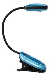
I’m a cheapskate so I bought one of the older style Kindles without a backlight, and took along a booklight. I have not had much luck with booklights over the years, they all seem pretty feeble and unreliable, but I had finally homed in on the Mighty Bright Miniflex lights which are just brilliant. I used to read kindle books on my phone or tablet but the battery life of the Kindle is a real bonus when you are away from home.
They are a bit clumsy, more of a general purpose clip light than a dedicated booklight, but we also bought one of the Mighty Bright Booklights which was very neat and packs small but nowhere near as generally useful.
So the booklight was left behind and the Miniflex was my constant companion, especially as lighting in India can be pretty feeble and it gets dark around 7pm every day. It was also great as a general purpose torch and the batteries lasted well.
Communication
Internet cafes are OK (variable quality) but wifi is better and available in some places we went so we took our cheap Android Phones (Samsung Galaxy W) even though they were locked to our UK network, very useful for email and online banking.
We used them occasionally for text messages but also bought a cheap Indian phone for the trip. This worked well but it took a long time to set up because of some bureaucracy confusion, largely because our hosts for the first fortnight were too helpful and that got in the way.
We would have been better just going to the nearest phoneshop but the important thing to remember is that you will need passport photos and copies of your passport details page and Indian Visa plus an Indian address where you are resident at that time in order to buy a phone. (NB You will need all that stuff several times when you are travelling in India so to save trouble, equip yourself with lots of photocopies and passport photos)
Get that all right, make sure the shop has filled in their forms correctly and you have all the same information to hand for when you complete the registration process and you should have your phone registered and working in two days.
The registration process required you to answer various questions from a human operator, the problem was that he could only tell from his computer if the answer was right or wrong so, because our host had given the phoneshop a different postal address to the one we had, we were completely stalled and had to go back to the shop, 15 km away. Everybody involved was very nice and helpful but if your answers didn’t join up with the original application form no deal.
A friend who had taken along an unlocked smartphone and bought an Indian Sim card (same process as above) was able to get affordable internet access so I would recommend having an unlocked smartphone, our son was about to buy a new phone and his good enough unlocked Samsung would have been available but he couldn’t get that organised before we left.
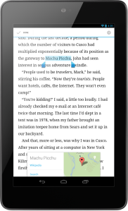
I also took my Nexus 7 tablet which was our main wifi tool, invaluable for managing financial stuff as well as email and general internet. We met some people who were relying on wifi access and tripadvisor to run their travels which seems crazy as proper travel guides are very helpful and enrich the experience, but the internet was useful as backup.
For future travels I’ll take an unlocked smartphone that has wifi tethering then we can get internet access from the phone network and share it with our other gadgets. eg that would let us download new Kindle books or use online Google maps on the tablet.
The Nexus tablet was brilliant and a great travel gadget with many uses, especially as it will double as a Kindle and also carry all your travel documents. Very nice size to have in a bar bag much nicer screen than the expensive iPad mini and of course you can only get offline Google maps on Android.
Navigation
I always like to have a good set of maps with me and I was also aware that we might be following roads that were not on any published map. So we had two things in mind: how to find our way around and how to record geographical information that might be added to Open Streetmap (OSM).
We printed off a great pile of maps from the internet as described in a previous post but also uploaded the offline Google maps for the areas we would visit so they could be viewed on the Nexus tablet. Unfortunately something went wrong with this, probably in the rush to get ready I wasn’t concentrating, and when we arrived in India the maps were not visible on the tablet.
Later on when we had wifi I loaded them again and it all worked fine, however the area where it would have really benefited us was the more crowded coastal region where we started the trip with a cookery course. We missed out on some cycling opportunities during the first two weeks, especially as we didn’t really know where we were for much of the time (our lovely hosts and most Indians seem very hazy about their local geography and you can’t just pick up a local map at the shops).
In the mountains, where we finally had wifi, there were relatively few roads and our paper maps were fine. The one time I consulted the offline maps with GPS on the Nexus it told me very confidently that we were right in the middle of an empty area with no mapped roads. This was absolutely correct and confirmed what we suspected but of little help.
Mapping and Recording the Journey
We have never had a cycle computer that worked well on the Pino, partly because the bike is regularly split in two for transport which compromises wired devices but also the wireless computers we tried could not cope with the distance between the rear handlebars and the front wheel. Also the devices we tried tended to need a lot of management and attention and required you to make a written note of each day’s travels before resetting for the next day..
Of course the simple answer to all that is a GPS computer but GPS bike computers are horribly expensive and come loaded with features that were of no interest to us, all concerned with monitoring performance and physiology.
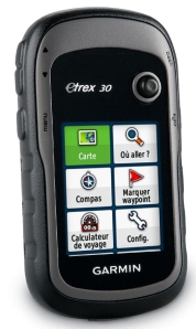 However I was hunting around and the penny dropped that the GPS units designed for walkers were actually ideal for cycle touring and it turns out that’s what serious cycle tourists use. We bought a Garmin eTrex 30 which has proved a great tool.
It provides a good trip computer, logging speed, distance etc, it measures climb and altitude (although that has to be taken with a pinch of salt as it’s affected by changes in the weather), you can leave it switched on all day so no worrying about management, and it compiles a complete record of where you have been and when.
The big advantages of a trekking GPS on a long bike tour are that it uses replaceable AA batteries as well as having a long battery life, joystick instead of touch screen, very rugged and half the cost of a bicycle unit.
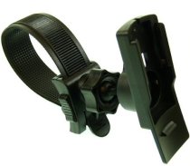 You can get bike mounts but for the odd handlebars on the Pino we bought a fancy motorcycle mount that could adjust to a variety of positions.
At the end of the trip we downloaded that record as a GPX file and could see straight away the whole history of our travels on Google maps (using the free gpx editor software). This was actually a very interesting and enjoyable chance to remember our journey. “Oh that was the day we were going all over town looking for…” The next step is that we can add those GPX tracks to Open Streetmap (OSM) where they can be used to improve the accuracy of existing mapping and allow previously unmapped roads to be added to OSM.
The eTrex 30 also has some useful navigation features that we did not use in India but I have been exploring since coming home. More about that another day. There’s a cheaper eTrex 20 which lacks the altimeter and compass but otherwise should do well. (June 2013 – I’ve now posted more detailed information about navigation and mapping with the etrex starting here)
The eTrex is much faster and more accurate than a phone in using GPS satellites but there are some uses for phone GPS as well. I found a very nice Android app called OSM Tracker which not only records where you have been but allows you to record images or voice notes at a location.
 This meant that it was possible to photograph road junctions and useful resources such as accommodation, shops and cafes or just street signs or town signs to help with mapping later. A photograph of a local business with the address and phone number on the sign is an invaluable aid to mapping. India is full of good-sized towns (locally called ‘villages’ but towns by European standards) that are not shown on any commercially available maps.
Not easy to use the phone camera in bright sunlight, even in the UK, but I’ve found this really useful. At the moment I’m using it to record the location of unreasonable barriers on cycle paths in the UK. Even while in India it was possible to track back on the phone and find the name and phone number of a nice looking guest house we had recorded so we could pass it on to friends who were going that way.
An alternative way of capturing all this stuff is to ensure that the clock and date in your normal camera are synchronised with your GPS unit, there is software that adds the GPS tags to the photographs you take.
That’s probably quite enough for one post, watch this space for more gadgets soon.
Tags: Communication, Cycletouring, Kerala, Navigation



Leave a comment